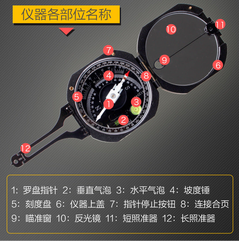
Harbin DQL-8Geological Compass Instrument Compass North Needle Tendency Inclination Vertical Angle Slope
Harbin DQL-8Geological Compass Instrument Compass North Needle Tendency Inclination Vertical Angle Slope
Couldn't load pickup availability


DQL-8 Geological Compass Instrument—Exploration, an Assistant for Professional Fields
In geological exploration, mining development, military surveying, and scientific research and teaching, directional measurement and terrain analysis are key to success.DQL-8 Geological Compass InstrumentWith its performance, portable design, and scientific engineering, it has become the tool of industry elites!
Core advantage: Stable and reliable
-
High Precision Measurement
-
Magnetic needle damping time ≤15 seconds, quickly and stably points to the magnetic meridian direction, reading error ≤0.5°, ensuring reliable data
。 -
Dual Scale Steering Wheel Design: The outer ring displays the tangent of the slope (0.05 degrees), and the inner ring shows the angle of inclination (1 degree), meeting diverse terrain requirements
。
-
-
Multifunctional Integration
-
Production statusEasily obtain rock layer orientation, inclination, and dip angle, supporting geological structure analysis
。 -
Topographic Surveying: Set Orientation, Measure Slope Angle, Set Horizontal Line, Suitable for Rapid Field Surveying
。 -
Vertical Angle Measurement:Can read vertical angles by sticking to the surface of objects, aiding in engineering and mining assessments
。
-
-
Humanized Design
-
Lightweight body (only 0.24-0.27kg), highly portable, suitable for complex environments such as mountains and caves
。 -
The reflector is linked with the long-distance sight, supporting target positioning at a distance, with intuitive and convenient operation
。
-
Application Scenario: Comprehensive Coverage in Multiple Fields
-
Geological Exploration: Quickly determine the formation of rock layers and analyze geological structural features.
-
Mining Development: Assess the direction of mineral bodies and optimize mining plans.
-
Military Surveying and Mapping: Field Orientation Positioning, Topographic Map Drawing and Navigation.
-
Scientific Research and Teaching: Practical tools for geology, surveying and mapping engineering and other disciplines.
Technical Highlights: Details Make the Difference in Professionalism
-
Magnetic Declination Adjustment: Supports regional magnetic declination calibration to ensure measurement results align with actual geographical coordinates
。 -
Anti-interference Design: Special magnetic needle structure reduces external magnetic field interference and enhances stability
。 -
Durable Protection: Agate bearings and anti-magnetic material extend service life and adapt to harsh environments
。
Reasons for Choosing DQL-8
-
AuthenticationComplies with Q/HGY06-2020 standard, quality assured
。 -
Manufacturer SupportProvide equipment sourcing and after-sales maintenance services for a one-stop solution, worry-free purchasing
。 -
Cost-effective ChoiceDomestic high-precision instruments, price negotiable, meeting both budget and performance requirements
。
Contact us immediately to obtain detailed specifications and trial experience of the DQL-8 Geological Compass!
Let professional tools empower your every survey!